Skip to content

Recent Posts

  • WKDW 97.5 FM to Stream Live Coverage During Hurricane Milton
  • Comparing Water Gauge Heights: Post-Hurricane Ian vs. Post-Hurricane Helene (Pre-Hurricane Milton), with Reflections on Hurricanes Charley (2004) and Irma (2017)
  • Hurricane Milton 2024
  • Promises Taste Bittersweet
  • How Long?

Most Used Categories

  • Water Report (23)
  • Breaking News (9)
  • Local Resources (3)
  • Power to THE PEOPLE (3)
  • Local Relief Efforts (2)
  • Traffic (1)
  • Spotlight (1)
Skip to content
  • Home
  • Hurricane Milton 2024
  • Hurricane Ian 2022
  • Contact
NorthPortNews@NorthPort.Tv
Subscribe
North Port TV

North Port TV

News for North Port, By North Port

Subscribe
  • Home
  • Hurricane Milton 2024
  • Hurricane Ian 2022
  • Contact
  • Home
  • Water Report
  • Big Slough Water Report – Tropicaire Blvd.

Big Slough Water Report – Tropicaire Blvd.

adminSeptember 30, 2022September 30, 2022

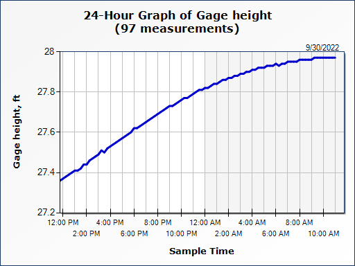
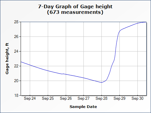
Water continues to flow down the Big Slough Waterway ( Latitude/Longitude: 27.12116528°, -82.19342389°). Readings, off of Tropicaire Bvld., put gage height at 27.97 Feet. Water levels in this area seem to be leveling off, but with more water flowing down from Central Florida, we could see this number rise over the next few days. This is as of 11:30 AM September 30th, 2022.

Post navigation

Next: Big Slough Water Report – West Price Blvd.

Related Posts

Water Report 10/1 6:00pm

October 1, 2022October 7, 2024 admin

Myakka River Water Report – Myakka State Park near Alligator Bridge 12:00pm 10/1

October 1, 2022October 7, 2024 admin

The Big Slough Water Report – Tropicaire Blvd. 12:00pm 10/01

October 1, 2022October 7, 2024 admin

Leave a Reply Cancel reply

Your email address will not be published. Required fields are marked *

Copyright All Rights Reserved | Theme: BlockWP by Candid Themes.