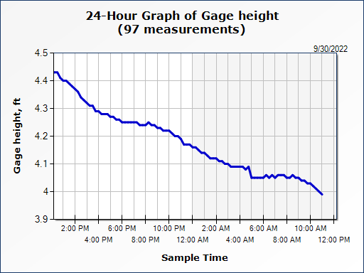
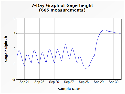
Skip to content

Recent Posts

  • WKDW 97.5 FM to Stream Live Coverage During Hurricane Milton
  • Comparing Water Gauge Heights: Post-Hurricane Ian vs. Post-Hurricane Helene (Pre-Hurricane Milton), with Reflections on Hurricanes Charley (2004) and Irma (2017)
  • Hurricane Milton 2024
  • Promises Taste Bittersweet
  • How Long?

Most Used Categories

  • Water Report (23)
  • Breaking News (9)
  • Local Resources (3)
  • Power to THE PEOPLE (3)
  • Local Relief Efforts (2)
  • Traffic (1)
  • Spotlight (1)
Skip to content
  • Home
  • Hurricane Milton 2024
  • Hurricane Ian 2022
  • Contact
NorthPortNews@NorthPort.Tv
Subscribe
North Port TV

North Port TV

News for North Port, By North Port

Subscribe
  • Home
  • Hurricane Milton 2024
  • Hurricane Ian 2022
  • Contact
  • Home
  • Water Report
  • Myakka River Water Report – U.S. 41 near Tarpon Point

Myakka River Water Report – U.S. 41 near Tarpon Point

adminSeptember 30, 2022September 30, 2022

The current Gage Height of the Tidal Myakka River is 3.99 Ft., falling from 4.4 Ft. over the last 24 hrs.

Post navigation

Previous: Big Slough Water Report – North Port Blvd.
Next: Myakka River Water Report – Control near Laurel, Florida

Related Posts

Water Report 10/1 6:00pm

October 1, 2022October 7, 2024 admin

Myakka River Water Report – Myakka State Park near Alligator Bridge 12:00pm 10/1

October 1, 2022October 7, 2024 admin

The Big Slough Water Report – Tropicaire Blvd. 12:00pm 10/01

October 1, 2022October 7, 2024 admin

Leave a Reply Cancel reply

Your email address will not be published. Required fields are marked *

Copyright All Rights Reserved | Theme: BlockWP by Candid Themes.